
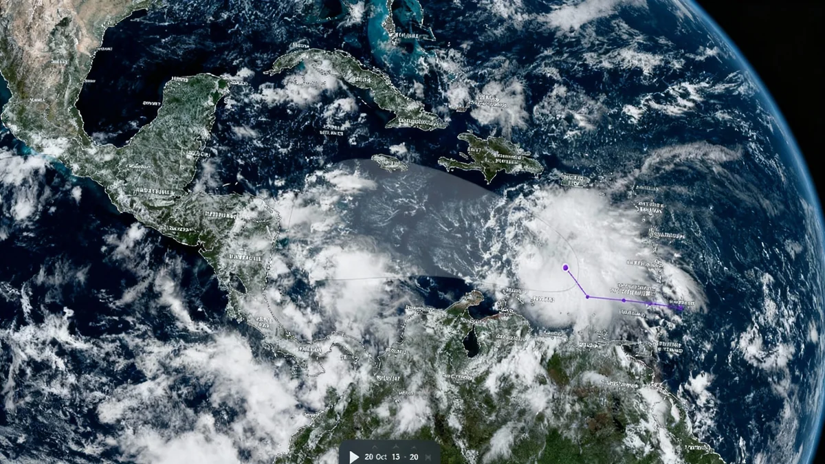
A rapidly organizing tropical wave moving through the eastern Caribbean Sea is on the verge of becoming the next named storm of the season. The system, designated AL98, now has a 90 percent chance of developing into a tropical depression or storm within the next few days, with 'Melissa' being the next name on the Atlantic list.
Forecasters at the National Hurricane Center (NOAA) are urging interests across the Greater Antilles to closely monitor the system's progress. Islands including Puerto Rico, Hispaniola, Jamaica, and Cuba could face significant weather impacts later this week.
Key Takeaways
- A tropical wave in the eastern Caribbean has a 90% chance of formation within the next seven days.
- The system is expected to be named Tropical Storm Melissa if it strengthens as predicted.
- Puerto Rico, Hispaniola, Jamaica, and Cuba are advised to monitor the storm's development.
- Immediate threats include heavy rainfall, gusty winds, and potential flooding, particularly for the ABC Islands.
System Gains Organization Over Caribbean Waters
The tropical disturbance, first identified on October 16, is showing increasing signs of organization. While recent satellite wind data confirmed it still lacks a fully closed circulation, the associated area of showers and thunderstorms has become more concentrated.
Surface observations indicate the system's circulation is gradually becoming better defined. As it continues its westward track into the central Caribbean, environmental conditions are expected to become more favorable for significant development.
According to the National Hurricane Center, a tropical depression or storm is now likely to form within the next one to two days. This prediction is based on the system's anticipated slowdown, which will give it more time over warm waters to strengthen.
Islands Brace for Potential Impact
Authorities have issued alerts for several Caribbean islands to prepare for adverse weather conditions. The primary concerns are heavy rainfall, strong winds, and rough surf, which could lead to flooding and dangerous coastal conditions.
Who Needs to Be on Alert?
The primary watch area includes the Greater Antilles, a group of the larger islands in the Caribbean Sea. Residents and visitors in the following locations should stay informed:
- Puerto Rico
- Hispaniola (comprising Haiti and the Dominican Republic)
- Jamaica
- Cuba
Additionally, the ABC Islands (Aruba, Bonaire, and Curaçao) could experience heavy rainfall and gusty winds over the next couple of days, regardless of whether the system achieves named-storm status.
The National Hurricane Center has explicitly warned that there is a risk of "heavy rain and flooding, strong winds, and rough surf later this week" for these areas. Residents are advised to review their emergency plans and secure any loose items around their properties.
From Tropical Wave to Named Storm
The journey from a disorganized wave to a named storm is a specific meteorological process. Currently, the system is a fast-moving tropical wave, a common feature during hurricane season originating off the coast of Africa.
Its initial rapid speed has so far inhibited significant development. However, as the system is forecast to slow its forward motion over the central Caribbean, conditions will become more conducive for it to organize further.
Formation Timeline
- Next 48 Hours: Medium chance of tropical development.
- Next 7 Days: High (90%) chance of tropical development.
If the system's maximum sustained winds reach 39 mph (63 km/h), it will be officially classified as a tropical storm and given the name Melissa. This would make it the 13th named storm of the Atlantic hurricane season.
Current Weather Warnings and Sea Conditions
In addition to the developing storm threat, a gale warning is already in effect for parts of the eastern Caribbean basin. This warning points to the immediate danger posed by the powerful tropical wave even before it fully forms.
Mariners are being warned of east to southeast winds reaching gale force, accompanied by heavy showers. These conditions create hazardous seas for all vessels in the area.
"A robust, fast-moving tropical wave will maintain gale E to SE winds and heavy showers at the eastern basin," a recent maritime forecast stated. The report also noted that rough seas from a northern swell will propagate through the Atlantic passages before subsiding.
The combination of the existing strong winds and the potential for a developing storm system creates a complex and dangerous weather scenario for the central Caribbean over the coming week. All interests in the region are strongly encouraged to stay updated with the latest advisories from the National Hurricane Center and local meteorological services.